RTK vs PPK Drones Explained: What Is the Difference in Drone Mapping?

RTK and PPK are two positioning methods used in professional drone mapping. They both help improve the accuracy of drone data, but they do it in different ways.

RTK corrects positioning during the flight.

PPK corrects positioning after the flight.

That simple difference affects workflow, reliability, setup, processing, equipment choice and how mapping data is handled.

For serious drone mapping, RTK and PPK matter because normal GPS-style positioning is not accurate enough for many professional outputs. A drone can take sharp images and produce an impressive-looking map, but if the image positions are poor, the final data may not be accurate enough for measurement, survey support, construction tracking or repeatable site comparison.

The important thing is not to treat RTK or PPK as magic. They improve positioning, but they do not replace good flight planning, suitable ground control checks, proper processing or professional judgement.

Quick Answer: RTK vs PPK

RTK stands for Real-Time Kinematic. It applies positioning corrections during the drone flight.

PPK stands for Post-Processed Kinematic. It applies positioning corrections after the flight, during post-processing.

FeatureRTKPPK
Full nameReal-Time KinematicPost-Processed Kinematic
Correction timingDuring the flightAfter the flight
Main advantageFaster field workflowMore flexible after data capture
Relies on live correction linkYesNo, not in the same way
Useful forReal-time corrected image positionsPost-flight corrected image positions
Common inConstruction mapping, inspection, site workSurvey-style workflows, difficult signal areas
Main riskLive correction link issuesMore post-processing work
Best for beginners to understand asCorrect nowCorrect later

The simplest way to remember it is:

RTK corrects in real time. PPK corrects afterwards.

Diagram comparing RTK and PPK drone mapping workflows

Why Drone Mapping Accuracy Matters

Drone mapping is not just about taking aerial photos. It is about collecting data that can be turned into maps, models and measurements.

If the positioning is poor, the outputs may still look impressive but be unsuitable for serious use.

Accuracy matters for:

  • construction progress mapping
  • stockpile volume calculations
  • earthworks
  • road and rail corridors
  • land surveying support
  • roof and building records
  • site measurement
  • asset inspection
  • repeat mapping over time
  • comparing one flight with another

A site map that looks sharp is not automatically accurate. A 3D model that looks detailed is not automatically positioned correctly. A point cloud with millions of points is not automatically suitable for measurement.

RTK and PPK are used to improve the positional accuracy of the data captured by the drone, especially in professional workflows.

What Is GNSS?

Before understanding RTK and PPK, it helps to understand GNSS.

GNSS stands for Global Navigation Satellite System. It is the broader term for satellite navigation systems such as GPS and other satellite constellations.

A normal drone uses satellite positioning to understand where it is. That is useful for navigation, Return to Home, hovering and recording approximate image locations.

But standard GNSS positioning is not always accurate enough for professional mapping. It can be affected by satellite geometry, atmospheric conditions, signal reflections, buildings, trees, terrain and other sources of error.

RTK and PPK improve this by using correction data.

What Is RTK?

RTK stands for Real-Time Kinematic.

In a drone mapping workflow, RTK corrects the drone’s positioning during the flight. The drone receives correction data while it is flying, which helps improve the accuracy of the image or sensor positions recorded during capture.

A typical RTK setup may involve:

  • an RTK-capable drone
  • a base station or network correction service
  • a reliable communication link
  • suitable GNSS reception
  • mapping software that can use the corrected data

The main appeal of RTK is speed and efficiency. If corrections are applied during the flight, the workflow can be cleaner and faster when everything is working properly.

RTK is common in professional mapping drones because it can make field operations more efficient and reduce the need for large numbers of ground control points in some workflows.

What Is PPK?

PPK stands for Post-Processed Kinematic.

Instead of correcting the drone’s position during the flight, PPK applies corrections afterwards. The drone records positioning data during the flight, and that data is corrected later using reference data.

A typical PPK workflow may involve:

  • a PPK-capable drone
  • raw GNSS data from the drone
  • reference data from a base station or correction source
  • post-processing software
  • a workflow for linking corrected positions to images or sensor data

The main appeal of PPK is flexibility. Because it does not depend on a live correction link in quite the same way as RTK, it can be useful where real-time corrections are unreliable, interrupted or difficult to maintain.

The trade-off is that PPK usually involves more work after the flight.

RTK vs PPK: Main Difference

The main difference between RTK and PPK is when corrections are applied.

RTK applies corrections in real time.

PPK applies corrections after the flight.

That difference affects how the operator works.

With RTK, you want the correction link working properly during the flight. If the link is stable, the drone records corrected positions as it flies.

With PPK, you collect the data first and correct it later. That can be useful if the site has poor communication, unreliable network coverage, obstacles or conditions that make a live correction link less dependable.

Neither method is automatically better in every situation. The right choice depends on the site, equipment, workflow, output and required accuracy.

RTK vs PPK Comparison Table

QuestionRTKPPK
When are corrections applied?During flightAfter flight
Does it need a live correction link?YesNot in the same way
Is it faster in the field?Often, yesOften slower overall due to post-processing
Is it more flexible after capture?Less flexibleMore flexible
What happens if signal drops?Corrections may be interruptedData can still be processed later if logged correctly
Is it good for repeat site mapping?YesYes
Does it remove the need for quality checks?NoNo
Does it replace good flight planning?NoNo
Does it guarantee survey accuracy?NoNo

The key message is simple: RTK and PPK are positioning tools. They help, but they do not make a poor mapping workflow reliable by themselves.

How RTK Works in Drone Mapping

In an RTK drone mapping workflow, the drone receives correction data while it is flying.

This correction data may come from a base station or correction network. The drone uses that information to improve the accuracy of its recorded position.

In practical terms, this means each photo or sensor reading can be tagged with more accurate location information at the time of capture.

A simplified RTK workflow looks like this:

  1. Set up the mapping mission.
  2. Connect the drone to a correction source.
  3. Confirm RTK status before take-off.
  4. Fly the mapping mission.
  5. Capture images or sensor data with corrected positions.
  6. Process the data in mapping software.
  7. Check accuracy and output quality.
RTK drone mapping workflow showing live correction data during flight

RTK is attractive because it can make the process efficient. If everything works, the corrected positions are available immediately and the post-processing workflow may be simpler.

How PPK Works in Drone Mapping

In a PPK workflow, the drone records raw positioning data during the flight. Corrections are applied later after the mission.

A simplified PPK workflow looks like this:

  1. Set up the mapping mission.
  2. Capture images or sensor data.
  3. Record the drone’s raw GNSS data.
  4. Obtain reference data from a base station or correction source.
  5. Process the drone data and reference data after the flight.
  6. Correct the image or sensor positions.
  7. Process the corrected dataset in mapping software.
  8. Check accuracy and output quality.
PPK drone mapping workflow showing post-flight correction process

PPK is useful because it is less dependent on maintaining a live correction link during the flight. That can be valuable on difficult sites, remote locations, areas with patchy coverage, or jobs where signal reliability is a concern.

The trade-off is that you need a more careful post-processing workflow.

Is RTK More Accurate Than PPK?

Not automatically.

RTK and PPK can both support high-accuracy drone mapping workflows. The final accuracy depends on the whole system, not just whether corrections happen during or after the flight.

Accuracy depends on:

  • drone and sensor quality
  • GNSS conditions
  • base station or correction source quality
  • flight height
  • image overlap
  • ground sampling distance
  • camera calibration
  • RTK or PPK workflow
  • ground control points
  • checkpoints
  • processing software
  • operator skill
  • how the output is validated

A well-executed PPK workflow can outperform a poorly executed RTK workflow. A good RTK workflow can be faster and accurate enough for many professional jobs.

The better question is not β€œwhich is more accurate?” but β€œwhich workflow is more reliable and suitable for this job?”

When RTK Is Better

RTK is often better when you want a faster, cleaner field workflow and reliable live corrections are available.

RTK can suit:

  • construction progress mapping
  • repeat site surveys
  • open sites with good sky visibility
  • jobs where fast turnaround matters
  • projects using compatible RTK drones and correction networks
  • mapping work where the operator wants corrected positions during the flight

RTK is attractive because it can reduce post-processing complexity. If the live correction link is stable, you can leave the site with corrected image positions already recorded.

That does not mean the job is finished in the field. The dataset still needs processing and quality checks. But RTK can make the overall workflow more efficient.

When PPK Is Better

PPK is often better when the live correction link may be unreliable or when the workflow is designed around post-processing.

PPK can suit:

  • remote sites
  • poor mobile data areas
  • sites with communication interruptions
  • longer mapping missions
  • survey-style workflows
  • jobs where post-processing control is preferred
  • situations where RTK link dropouts are a concern

PPK is useful because the correction process happens after the flight. As long as the right data is recorded, there is more flexibility to correct and process the dataset later.

This can be valuable where reliability matters more than speed.

Do You Still Need Ground Control Points?

Sometimes, yes.

RTK and PPK can reduce the need for lots of ground control points, but they do not remove the need for accuracy checks.

Ground control points, or GCPs, are marked points on the ground with known coordinates. They can help georeference the model and improve accuracy.

Checkpoints are also important. A checkpoint is used to test accuracy rather than control the model. It helps show whether the output is actually performing as expected.

For professional mapping, it is risky to assume that RTK or PPK automatically makes ground control irrelevant. The need for GCPs depends on the job, required accuracy, site conditions, equipment, client expectations and whether the output is being used for measurement.

A sensible approach is:

  • use RTK or PPK to improve image positioning
  • use checkpoints to verify accuracy
  • use GCPs where the job requires stronger control
  • document the workflow and limitations

RTK, PPK and Ground Control Compared

MethodWhat It DoesMain Role
RTKCorrects drone positioning during flightImproves real-time image/sensor positions
PPKCorrects drone positioning after flightImproves positions during post-processing
GCPsKnown points on the ground used in processingHelps control/georeference the model
CheckpointsKnown points used to test accuracyHelps validate the output
Drone mapping diagram showing ground control points and checkpoints

RTK and PPK improve the drone’s position data. GCPs and checkpoints help control and verify the mapping output.

They are not enemies. In serious work, they can complement each other.

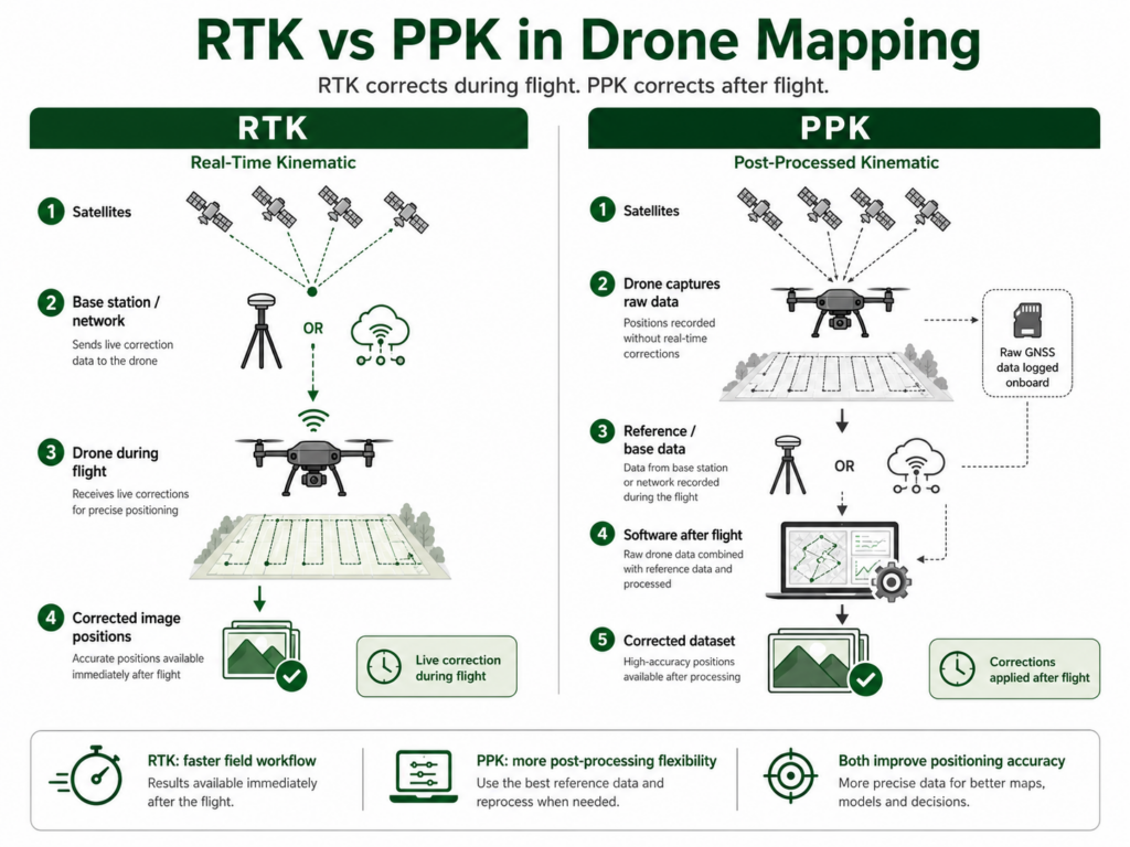
RTK vs PPK for Photogrammetry

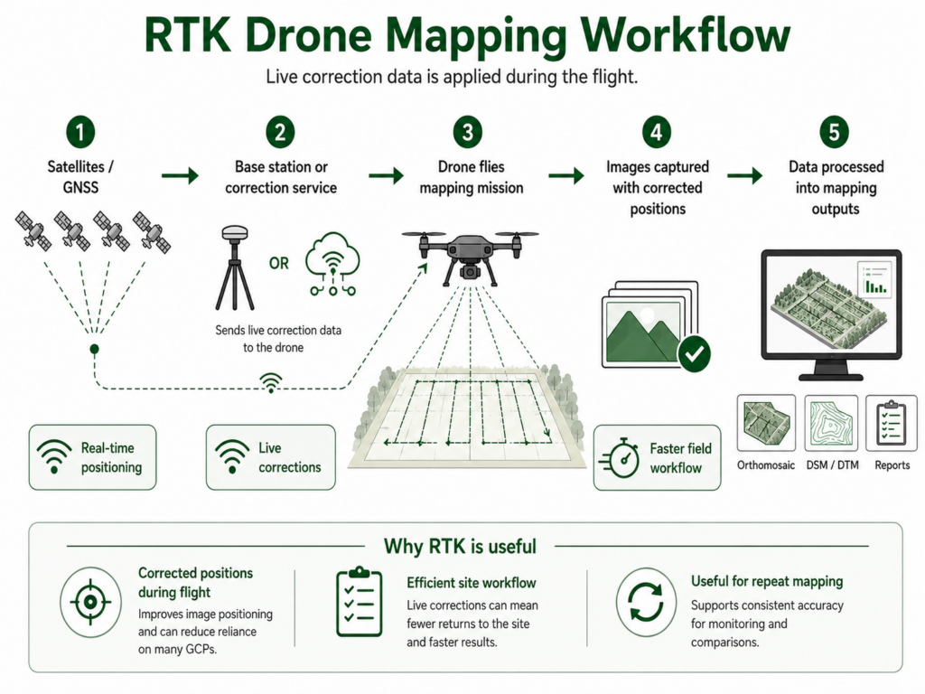
RTK and PPK are both commonly used in drone photogrammetry.

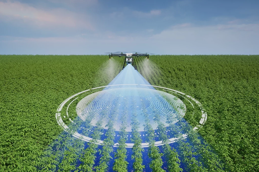
In photogrammetry, the drone captures overlapping images. RTK or PPK improves the position information attached to those images.

This can help the mapping software align and georeference the project more accurately.

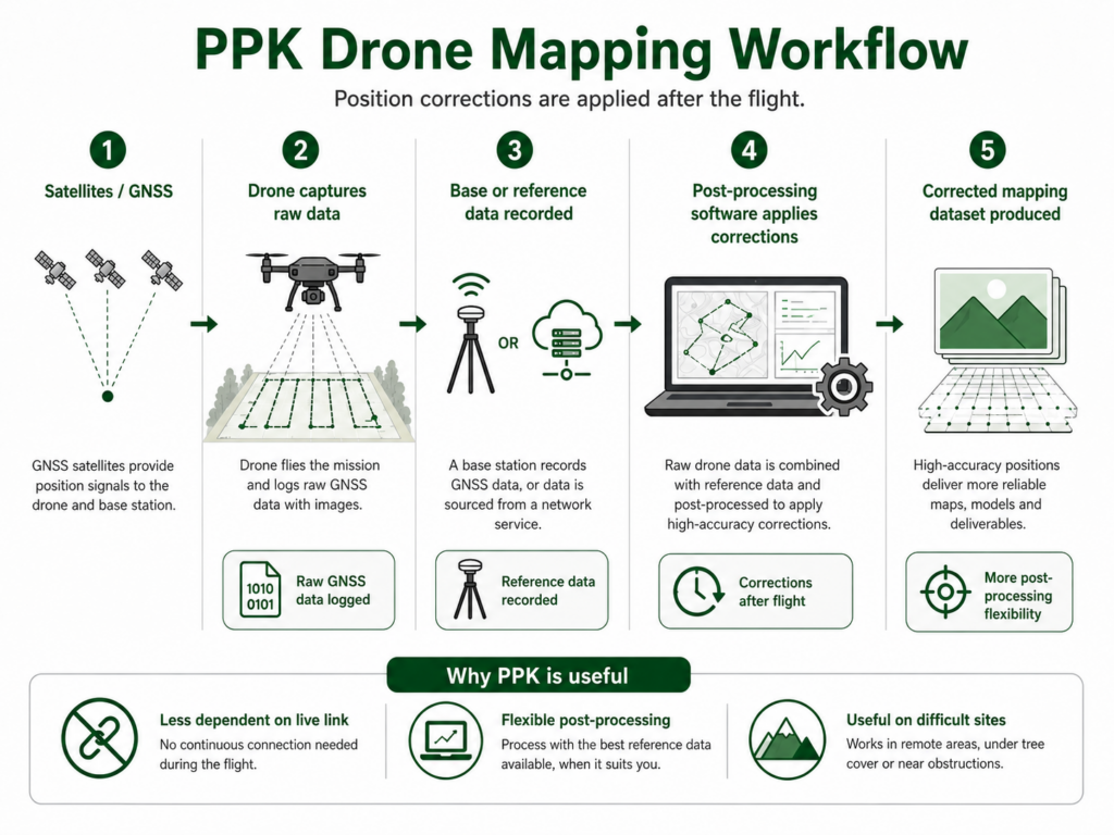
RTK can be useful when the operator wants faster turnaround and reliable real-time correction. PPK can be useful where post-processing flexibility is preferred.

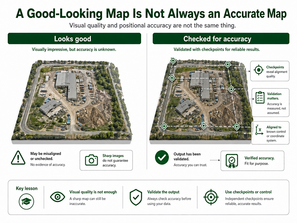
Photogrammetry still depends on image quality. RTK or PPK will not fix poor overlap, blurry images, bad lighting, low texture or weak processing settings.

The position data is important, but it is only one part of the workflow.

πŸ‘‰ Photogrammetry vs LiDAR

RTK vs PPK for LiDAR

LiDAR workflows also depend heavily on accurate positioning.

A drone LiDAR system collects laser measurements as the drone moves. To build a useful point cloud, the system needs to know where the sensor was and how it was moving at the time the data was captured.

That is why GNSS, IMU data, RTK, PPK and calibration are so important in LiDAR workflows.

RTK can support real-time positioning. PPK can support more refined post-flight correction. The right workflow depends on the equipment, site and processing requirements.

LiDAR is not automatically accurate just because it is LiDAR. It still needs a strong positioning workflow and proper processing.

πŸ‘‰ Drone LiDAR Mapping Explained

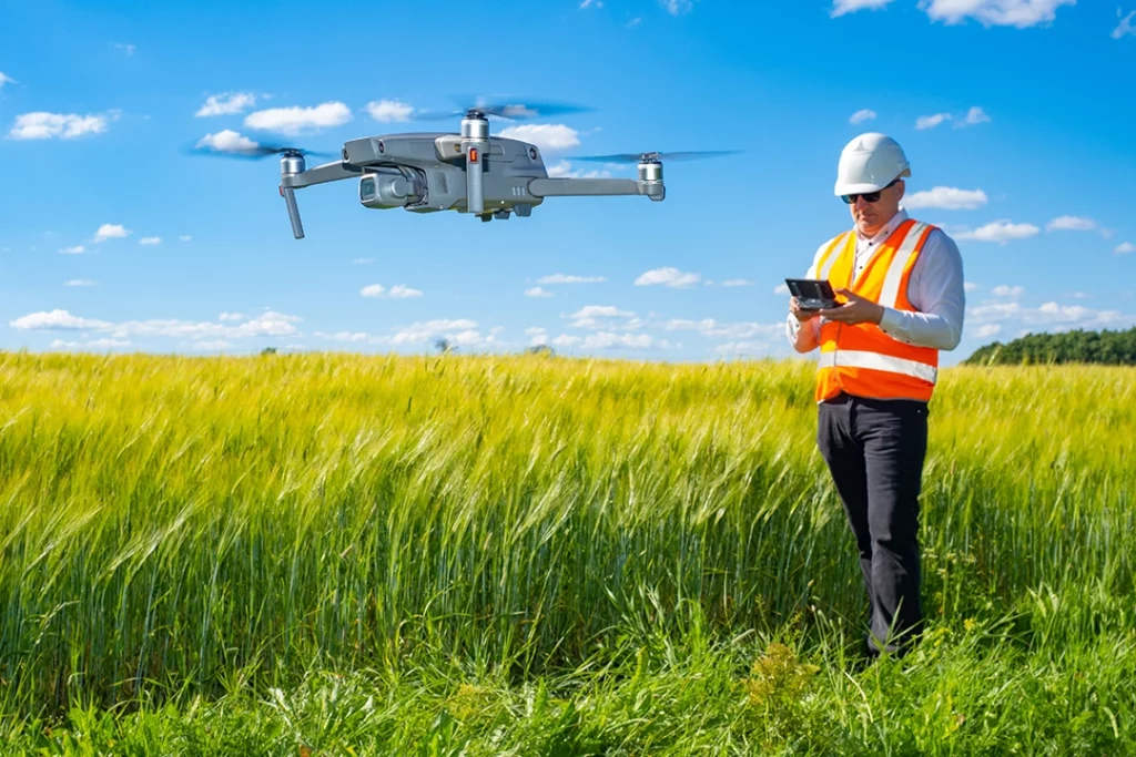
Which Drones Use RTK or PPK?

RTK and PPK are usually found on more professional drone platforms rather than basic beginner drones.

Examples of RTK-style mapping drones and platforms include enterprise-focused drones used for surveying, construction, inspection, agriculture and mapping. DJI’s enterprise range includes RTK-capable options, and other manufacturers also build drones specifically for mapping and surveying workflows.

Consumer drones can be useful for learning mapping concepts, but RTK/PPK capability is one of the things that separates casual mapping from more serious professional data capture.

When comparing drones for mapping, look at:

  • RTK compatibility
  • PPK workflow support
  • camera quality
  • mechanical shutter where relevant
  • flight planning support
  • mapping software compatibility
  • battery life
  • payload options
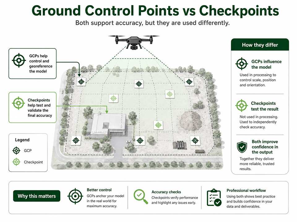
  • support for ground control and checkpoints
  • export formats

πŸ‘‰ Best Drone for Mapping UK

RTK Drone vs Normal GPS Drone

A normal GPS drone can record where each photo was taken, but the positional accuracy is limited.

An RTK drone improves that position data using correction information.

That does not automatically mean every RTK dataset is survey-grade, but it does mean the drone is built for more accurate mapping workflows than a normal consumer GPS drone.

A normal GPS drone may be enough for learning, visual records or basic mapping practice. An RTK drone becomes more important when accuracy, repeatability and professional outputs matter.

Do Beginners Need an RTK Drone?

Not usually.

If you are just learning drone mapping, start by understanding photogrammetry, overlap, orthomosaics, point clouds and mapping software.

An RTK drone becomes more relevant when you want to produce professional outputs, compare repeat flights, reduce manual ground control work, or work on jobs where location accuracy matters.

For beginners, the better learning path is:

  1. Learn basic drone flying.
  2. Understand drone mapping.
  3. Learn photogrammetry.
  4. Learn orthomosaics and point clouds.
  5. Learn ground control and checkpoints.
  6. Then learn RTK and PPK.

Do not buy an RTK drone just because the term sounds professional. Buy one when the workflow requires it.

Do You Need RTK or PPK for Drone Surveying?

For serious survey-style work, RTK or PPK is often important, but it is not the whole answer.

Surveying is not just a drone feature. It is a professional workflow involving equipment, control, accuracy, processing, interpretation and liability.

A drone with RTK can support survey workflows, but that does not automatically make every output a professional survey. The result depends on the method, checks and competence behind it.

This distinction matters. Drone mapping can support surveying, but it should not be oversold.

RTK, PPK and UK Drone Rules

RTK and PPK are technical positioning methods. They do not change the legal category of the flight by themselves.

In the UK, the rules still depend on the drone, location, weight, class, operation and risk level. Some mapping work may be possible in the Open Category, but more complex work may fall into the Specific Category.

Professional mapping may also require insurance, site permissions, risk assessments, operational authorisation, suitable pilot competency and proper planning.

The UK CAA states that the Specific Category covers operations that are more complex than allowed in the Open Category. So for serious mapping or commercial site work, the technical mapping workflow and the operational rules both need to be considered.

πŸ‘‰ Do You Need a Licence to Fly a Drone in the UK?

πŸ‘‰ Flyer ID vs Operator ID Explained

Common Mistakes Beginners Make With RTK and PPK

Thinking RTK Means No Ground Control

RTK can reduce ground control requirements, but it does not automatically remove the need for checkpoints or validation.

Diagram explaining why a good-looking drone map is not always accurate

Thinking PPK Is Always More Accurate

PPK can be excellent, but it still depends on the quality of the recorded data, reference data, processing and workflow.

Ignoring Checkpoints

Checkpoints are one of the best ways to prove whether the output is accurate. Without checks, you are trusting the workflow rather than verifying it.

Confusing Relative and Absolute Accuracy

A model may be internally consistent but poorly positioned in the real world. Professional users need to understand the difference between how well the model fits itself and how well it fits real-world coordinates.

Buying an RTK Drone Too Early

RTK is useful, but it is not the first thing most beginners need. Learn mapping fundamentals first.

Treating Drone Mapping as Automatic Surveying

A drone can collect data for survey-style outputs, but proper surveying depends on method, control, checks and professional competence.

Ignoring Software Compatibility

Not every drone, camera or dataset works smoothly with every mapping software. Check compatibility before building a workflow around RTK or PPK.

What to Learn Next

RTK and PPK sit inside the wider drone mapping workflow.

Once you understand the difference, the next useful topics are:

  • ground control points
  • checkpoints
  • orthomosaics
  • point clouds
  • photogrammetry accuracy
  • LiDAR positioning
  • drone mapping software
  • best RTK drones
  • best drones for mapping

πŸ‘‰ Drone Mapping Explained for UK Beginners

πŸ‘‰ What Is a Drone Orthomosaic?

πŸ‘‰ What Is a Drone Point Cloud?

πŸ‘‰ Best RTK Drone UK

Final Verdict: RTK vs PPK

RTK and PPK both improve drone mapping accuracy by correcting positioning data.

RTK applies corrections during the flight. PPK applies corrections after the flight.

RTK is often better when you have a reliable correction link and want a faster field workflow. PPK is often better when you want more post-processing flexibility or when live corrections may be unreliable.

Neither method guarantees accuracy on its own. Good drone mapping still depends on flight planning, image quality, positioning, ground control, checkpoints, processing and knowing what accuracy the job actually requires.

For beginners, learn photogrammetry and mapping fundamentals first. For serious professional mapping, RTK and PPK become important parts of the workflow.

FAQ

What is RTK in drone mapping?

RTK stands for Real-Time Kinematic. It applies positioning corrections during the drone flight to improve the accuracy of image or sensor positions.

What is PPK in drone mapping?

PPK stands for Post-Processed Kinematic. It applies positioning corrections after the flight using recorded drone data and reference data.

What is the difference between RTK and PPK?

RTK corrects positioning during the flight. PPK corrects positioning after the flight. RTK depends more on a live correction link, while PPK gives more post-processing flexibility.

Is RTK better than PPK?

Not always. RTK can be faster when the correction link is reliable. PPK can be better when live corrections are unreliable or when the workflow benefits from post-processing flexibility.

Is PPK more accurate than RTK?

Not automatically. Both can support accurate mapping. Final accuracy depends on the equipment, workflow, site conditions, processing and quality checks.

Do RTK drones need ground control points?

Sometimes. RTK can reduce the need for ground control points, but checkpoints are still important for validating accuracy. Some jobs still need GCPs.

Do PPK drones need ground control points?

Sometimes. PPK improves positioning after the flight, but GCPs or checkpoints may still be needed depending on the accuracy requirements.

What are checkpoints in drone mapping?

Checkpoints are known points used to test the accuracy of the final output. They are not used to control the model in the same way as GCPs.

Can a normal GPS drone be used for mapping?

Yes, a normal GPS drone can be used to learn mapping concepts and create basic visual outputs. For professional accuracy, RTK, PPK, GCPs and better workflows may be needed.

Do beginners need an RTK drone?

Not usually. Beginners should first learn flying, photogrammetry, overlap, orthomosaics and mapping software. RTK becomes more important when accuracy and repeatable professional outputs matter.

Is RTK useful for photogrammetry?

Yes. RTK can improve the position information attached to drone images, which can help with georeferencing and mapping accuracy.

Is PPK useful for LiDAR?

Yes. LiDAR workflows depend heavily on accurate positioning, and PPK can be useful for correcting positioning data after the flight.

Does RTK make a drone survey-grade?

No. RTK is useful, but survey-grade outputs depend on the whole workflow, including control, checks, processing, equipment and professional competence.

Can RTK and PPK be used together?

Some workflows may use elements of both or have fallback options depending on the equipment and processing method. The important thing is to understand how corrections are applied and validated.

Does RTK or PPK change UK drone laws?

No. RTK and PPK are positioning methods. UK drone rules still depend on the operation, location, drone, risk level and CAA category.