Drone inspections are one of the most practical uses of drone technology. Instead of sending a person straight onto a roof, scaffold, ladder, mast, tower, industrial structure or difficult site, a drone can capture detailed images, video, thermal data or mapping outputs from the air.
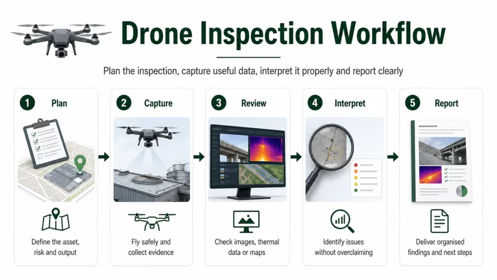
That does not mean drones replace inspectors. A drone is a data capture tool. The value comes from what it can safely see, how well the data is captured, and how accurately the results are interpreted.
Used properly, drones can improve access, reduce unnecessary working at height, create better visual records, and help identify areas that need closer inspection. Used badly, they can produce impressive-looking images that prove very little.
This guide explains how drone inspections work, what they can be used for, which sensors matter, and where thermal imaging, LiDAR, mapping and normal camera drones fit into professional inspection workflows.
👉 Thermal Imaging Drones Explained
👉 Drone LiDAR Mapping Explained
👉 Drone Mapping Explained for UK Beginners
Table of Contents
ToggleQuick Answer: What Is a Drone Inspection?
A drone inspection uses a drone to capture visual, thermal or spatial data about a building, roof, structure, site, asset or area that needs checking.
Drone inspections are commonly used for:
- roofs
- chimneys
- gutters
- solar panels
- buildings and facades
- industrial sites
- construction sites
- bridges and infrastructure
- towers, masts and utilities
- land, drainage and access routes
- difficult or unsafe areas
The drone can capture close-up photos, video, thermal images, maps, 3D models, point clouds or annotated inspection records.
The important point is that the drone does not automatically diagnose the problem. It captures evidence. The quality of the inspection depends on the sensor, flight conditions, image quality, access, reporting method and the person interpreting the data.
Why Drones Are Used for Inspections
Drones are useful for inspections because they can reach areas that may be difficult, costly, slow or risky to inspect from the ground.
A drone can often provide a fast visual overview before anyone commits to ladders, scaffolding, cherry pickers, rope access or physical roof access. That does not remove the need for safe access in every case, but it can help decide what is actually needed.
The main benefits are:
- safer initial inspection of hard-to-reach areas
- faster visual access
- useful photo and video records
- less disruption on some sites
- ability to inspect roofs, elevations and structures from multiple angles
- better documentation for clients, insurers or maintenance teams
- thermal data where heat patterns matter
- mapping outputs where site context matters
The best drone inspections are not just “fly up and take some photos”. They are planned around the question being asked. A roof leak, solar fault, cracked chimney, blocked gutter, damaged cladding panel and overheating electrical component all need different data.
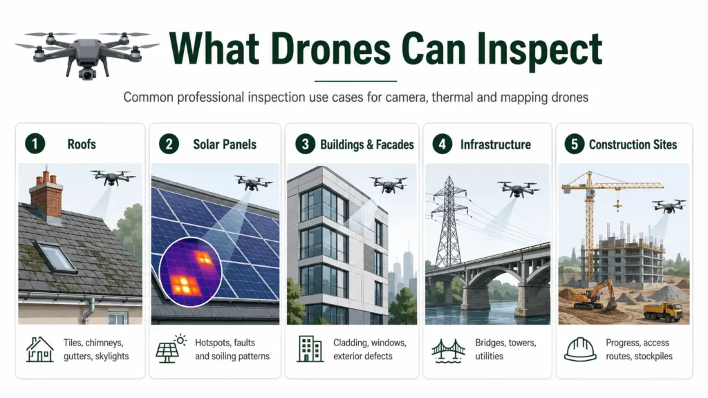
What Can Drones Inspect?
Drones are used across a wide range of inspection jobs. The right drone, sensor and workflow depend on the asset being inspected.
Roofs
Drones can inspect pitched roofs, flat roofs, tiles, slates, ridge lines, valleys, chimneys, flashing, gutters, skylights, leadwork, rooflights and roof-mounted equipment. They are especially useful for initial roof condition checks and hard-to-access areas.
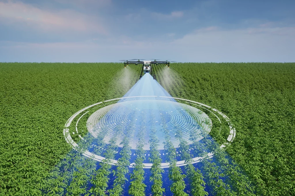
Solar panels
Drones can capture visual and thermal data across roof-mounted or ground-mounted solar arrays. Thermal imaging can help identify abnormal hotspots that may need closer investigation.
Buildings and facades
Drones can inspect cladding, brickwork, render, windows, parapets, roof edges, high-level details, signage, vents and weather-exposed surfaces.
Chimneys and gutters
A drone can provide a close visual view of chimney stacks, pots, flaunching, pointing, leadwork, gutters and downpipe access points without immediately needing someone to climb.
Industrial sites
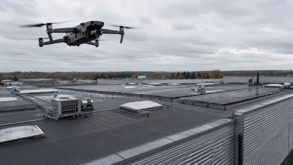
Drones can support inspection of warehouses, factories, tanks, yards, plant areas, roofs, pipe routes and difficult external structures.
Infrastructure
Drones are used around bridges, rail corridors, roads, towers, masts, powerlines, utilities and other infrastructure where access, height or safety are significant factors.
Construction sites
Drone inspections can help document progress, identify visible issues, record site conditions, map access routes, monitor stockpiles and support communication between teams.
Drone Inspection Is Not the Same as a Physical Survey
This distinction matters.
A drone inspection can show a lot, but it cannot physically touch, test, lift, scrape, probe, open, dismantle or sample anything. It can capture evidence and highlight areas for closer inspection, but it cannot replace every kind of hands-on survey.
For example, a drone may show cracked roof tiles, missing ridge mortar, blocked gutters or a suspicious flat-roof thermal pattern. But confirming the underlying cause may still need a roofer, surveyor, electrician, solar engineer or other competent professional.
A good drone inspection should be honest about what the images show and what they do not prove.
A drone can help answer:
- What is visible from above?
- Is there obvious damage?
- Which areas need closer inspection?
- Is there a pattern worth investigating?
- Can the condition be documented clearly?
- Has something changed since the last inspection?
It should not overclaim:
- confirmed leak source without evidence
- structural safety based only on photos
- electrical fault based only on a heat image
- roof condition where key areas were hidden
- survey-grade accuracy without suitable workflow
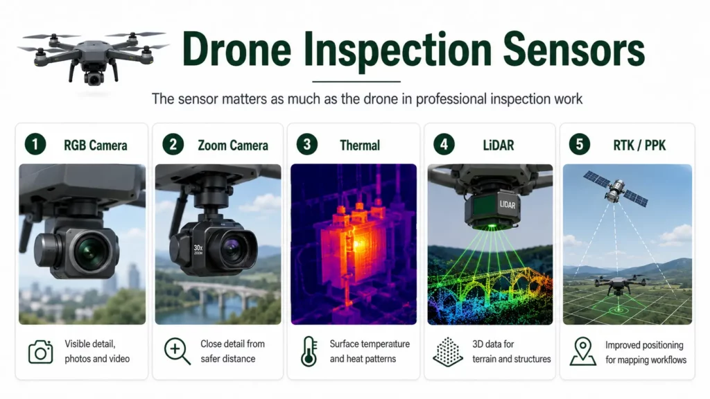
Sensors Used for Drone Inspections
The sensor matters as much as the drone. Different inspection tasks need different types of data.
RGB camera
The standard visual camera is still the most common drone inspection sensor. It captures normal photos and video.
A good RGB camera is useful for:
- roof damage
- gutters
- chimneys
- cladding
- external building condition
- construction progress
- visible solar panel damage
- site records
- general inspection photography
For many inspections, a sharp visual image is the most important output.
Zoom camera
A zoom camera allows the drone to capture detail from further away. This can be useful when the drone cannot safely fly close to a structure or when the operator needs to keep more distance from obstacles.
Zoom can help inspect:
- chimneys
- masts
- towers
- roof details
- facade defects
- high-level fixings
- industrial assets
Optical zoom is generally more useful than simply cropping a low-resolution image after capture.
Thermal camera
A thermal camera detects surface temperature differences. It can be useful for solar panel inspections, heat loss patterns, electrical hotspots, moisture indicators and fire response.
Thermal imaging is powerful, but it needs interpretation. It does not see through walls or roofs. It shows surface temperature patterns that may indicate an issue.
👉 Thermal Imaging Drones Explained
LiDAR
LiDAR uses laser measurements to create 3D point cloud data. It is more common in mapping, surveying, infrastructure and terrain workflows than simple roof inspections.
LiDAR may be useful for:
- infrastructure
- terrain
- vegetation
- corridors
- complex structures
- survey-style workflows
- 3D asset documentation
👉 Drone LiDAR Mapping Explained
RTK and positioning
RTK and PPK help improve positioning accuracy in mapping workflows. They are more relevant when the inspection requires repeatable positioning, mapping outputs, orthomosaics, point clouds or measured site data.
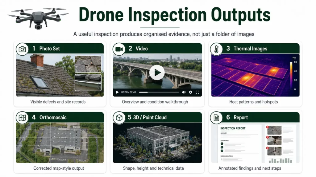
Drone Inspection Outputs
A drone inspection can produce several types of output. The right output depends on the job.
| Output | Best For |
|---|---|
| Photo set | Roofs, gutters, chimneys, facades, visible defects |
| Video | General condition, access routes, overview footage |
| Annotated images | Highlighting defects, hotspots or areas of concern |
| Thermal images | Heat patterns, solar hotspots, roof moisture indicators |
| Orthomosaic | Site maps, roof layout, construction context |
| 3D model | Building shape, roof layout, visual context |
| Point cloud | 3D mapping, terrain, structures, technical workflows |
| Inspection report | Combining evidence, notes, photos and recommendations |
For simple inspections, a well-organised photo set may be enough. For technical work, the output may need thermal analysis, mapping data, annotations, measurements or a structured report.
👉 What Is a Drone Orthomosaic?
👉 What Is a Drone Point Cloud?
Drone Roof Inspections
Roof inspections are one of the most common drone inspection uses.
A drone can capture roof areas that may be difficult or unsafe to view from the ground, including:
- slipped tiles
- cracked slates
- broken ridge tiles
- missing mortar
- damaged flashing
- chimney defects
- blocked gutters
- moss and debris build-up
- flat roof ponding
- skylight and rooflight condition
- solar panel layout and access issues
For an initial roof inspection, a drone can be extremely useful. It can help decide whether a roofer, scaffold or closer physical inspection is needed.
However, a drone roof inspection has limits. It may not show the underside of roof coverings, hidden membrane defects, internal damp paths, structural movement, timber condition or issues hidden by parapets, overhangs or solar panels.
A sensible roof inspection workflow may combine drone images, ground-level inspection, internal evidence, moisture checks and physical access where needed.
👉 Best Drone for Roof Inspections UK
Drone Solar Panel Inspections
Solar panel inspections are a strong use case for drones, especially when thermal imaging is involved.
A drone can inspect large arrays from above and capture both visual and thermal data. This can help identify panels, strings or areas that need closer investigation.
Thermal drone inspections may help highlight:
- panel hotspots
- possible cell defects
- shading issues
- soiling patterns
- string problems
- connection faults
- underperforming areas
- damaged panels
Thermal anomalies should be interpreted carefully. A hotspot is not automatically a confirmed fault. Conditions such as irradiance, wind, angle, panel temperature, reflections and time of day all affect the result.
For professional solar inspection work, radiometric thermal data, correct conditions and clear reporting are important.
👉 Best Drone for Solar Panel Inspections UK
Drone Building and Facade Inspections
Drones can be useful for external building inspections, especially where the building is tall, awkward, weather-exposed or difficult to access.
They can inspect:
- brickwork
- render
- cladding
- window surrounds
- parapets
- roof edges
- gutters
- vents
- high-level fixings
- signs
- flashing
- external plant
For visible defects, a high-resolution RGB camera or zoom camera may be the most useful sensor. For heat loss, moisture indicators or insulation patterns, thermal imaging may add another layer of information.
A drone can document what is visible, but it does not replace a qualified building survey where deeper diagnosis is needed.
Drone Infrastructure Inspections
Infrastructure inspections can involve more complex drone workflows.
Drones may be used around:
- bridges
- roads
- railways
- utilities
- powerlines
- telecoms masts
- towers
- pipelines
- industrial structures
- retaining walls
- drainage channels
These inspections often require careful planning because the operating environment may be more difficult. There may be people, roads, rail corridors, controlled sites, electromagnetic interference, restricted access, airspace considerations or safety procedures.
For infrastructure, useful sensors may include RGB cameras, zoom cameras, thermal cameras, LiDAR and mapping systems.
The right drone depends on the inspection target and the distance, detail, safety and data requirements.
Drone Construction Site Inspections
Drones are useful on construction sites because they can document progress and site condition from above.
They can help record:
- earthworks
- access routes
- drainage areas
- stockpiles
- roof progress
- material storage
- site layout
- temporary works
- building progress
- contractor activity
- before-and-after comparisons
For simple site records, normal drone imagery may be enough. For measurable mapping outputs, orthomosaics, point clouds, RTK workflows or photogrammetry software may be needed.
Drone data can be especially useful when repeated regularly because it creates a visual timeline of the site.
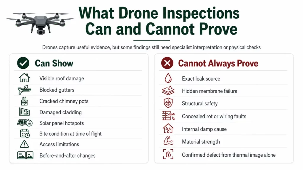
What Drone Inspections Can Prove
Drone inspections can provide strong visual evidence when the issue is visible from the air.
They can often show:
- missing or damaged roof materials
- blocked gutters
- cracked chimney pots
- visible facade defects
- damaged cladding
- obvious solar panel damage
- visible site condition
- thermal anomalies
- access limitations
- before-and-after changes
- roof and building layout
- condition at the time of inspection
Drone images are useful because they create a record. That record can be reviewed, shared, annotated and compared later.
For many maintenance and inspection tasks, that is valuable.
What Drone Inspections Cannot Prove
Drone inspections have limits.
They may not prove:
- the exact source of a leak
- whether a hidden membrane has failed
- structural safety
- internal damp cause
- hidden wiring problems
- concealed rot
- the condition beneath roof coverings
- electrical faults without further testing
- material strength
- whether a thermal anomaly is definitely a defect
A drone can show evidence. It can highlight likely issues. It can improve access and documentation. But the final diagnosis may still need a competent specialist.
This is not a weakness of drone inspections. It is simply the difference between remote data capture and full physical investigation.
Choosing the Right Drone for Inspections
The right drone depends on the inspection work.
For basic roof and building photography, a compact camera drone with good image quality may be enough.
For roof details, chimneys, towers and facades, zoom may be important.
For solar panels, heat loss and electrical hotspots, thermal capability matters.
For mapping, construction sites and measured outputs, RTK, photogrammetry support and mapping software compatibility become more important.
For infrastructure and complex 3D work, enterprise platforms, LiDAR, zoom cameras or specialist payloads may be needed.
The most important buying question is not “which drone is best?” It is “what does the inspection need to show?”
👉 Best Drone for Roof Inspections UK
👉 Best Thermal Drone UK
👉 Best Drone for Mapping UK
UK Rules for Professional Drone Inspections
Drone inspection work in the UK must be planned around the rules, not just the equipment.
The legal requirements depend on the drone, location, weight, class, airspace, people nearby, the operating environment and the level of risk.
Some low-risk drone work may fit within the Open Category. More complex operations may require Specific Category authorisation, insurance, site permission, risk assessment and suitable pilot competency.
This is especially relevant for inspections near buildings, people, roads, industrial sites, commercial premises, construction sites or infrastructure.
Privacy and data protection also matter. Drone inspections may capture neighbouring properties, people, vehicles, business sites or sensitive locations. Professional work should be planned and handled responsibly.
This guide is for general technical information only and is not legal advice. Anyone carrying out professional drone inspections in the UK should check current CAA guidance and make sure the operation is properly planned and authorised.
👉 Do You Need a Licence to Fly a Drone in the UK?
👉 Flyer ID vs Operator ID Explained
Is an Inspection Drone Worth Buying?
An inspection drone is worth buying when the work genuinely benefits from aerial access, safer data capture or better documentation.
It may be worth it for:
- roof inspection work
- solar panel inspection
- building surveys
- estate management
- construction progress
- industrial inspection
- infrastructure work
- utilities
- maintenance teams
- thermal inspection workflows
It may not be worth it if the buyer only needs occasional basic photos, casual flying or simple visual checks that can be done safely from the ground.
The cost of the drone is only part of the decision. A serious inspection setup may also need spare batteries, suitable insurance, training, software, reporting workflow, thermal capability, zoom capability, RTK, cases, tablets and maintenance.
A good buying decision starts with the inspection output required, then works backwards to the drone and sensor.
Common Drone Inspection Mistakes
There are several mistakes that can reduce the value of a drone inspection.
One mistake is treating the drone as the inspector. The drone captures data; the person interpreting the data still matters.
Another mistake is using the wrong sensor. A standard camera may be enough for visible roof damage, but not for thermal inspection. A thermal camera may show heat patterns, but not normal visual detail. A zoom camera may be more useful than flying dangerously close.
Poor flight timing is another issue. Thermal inspections, solar inspections and shadow-sensitive visual inspections can all be affected by time of day, weather and light.
It is also easy to overclaim results. A drone image can show a suspected issue, but it may not prove the cause.
Finally, some people forget the reporting stage. An inspection is more useful when images are organised, labelled, annotated and explained clearly.
Final Verdict: Why Drone Inspections Matter
Drone inspections matter because they improve access, safety, speed and documentation.
They are especially useful for roofs, solar panels, buildings, facades, construction sites, infrastructure and difficult-to-access assets.
The best drone inspections are not just about flying a drone near something and taking pictures. They depend on choosing the right sensor, flying in the right conditions, capturing useful evidence and interpreting it properly.
A drone can reduce unnecessary access risk, show areas that are difficult to see from the ground, and create clear records for maintenance, reporting and decision-making.
But drones do not replace professional judgement. They support it.
For many inspection jobs, the right approach is a combination of drone imagery, thermal data, mapping outputs, physical checks and competent interpretation.
FAQ
What is a drone inspection?
A drone inspection uses a drone to capture images, video, thermal data or mapping outputs of a building, roof, structure, site or asset.
What can drones inspect?
Drones can inspect roofs, chimneys, gutters, buildings, solar panels, construction sites, industrial sites, towers, masts, bridges, utilities and infrastructure.
Are drones good for roof inspections?
Yes, drones are useful for initial roof inspections and visual records. They can show tiles, slates, gutters, chimneys, flashing and flat roof areas, but they do not replace every physical inspection.
Can drones find roof leaks?
Drones can help identify visible roof issues and thermal patterns that may be associated with moisture, but they cannot always confirm the exact source of a leak.
Are drones useful for solar panel inspections?
Yes. Drones are especially useful for solar inspections when combined with thermal imaging. They can help identify hotspots and panels that may need closer investigation.
What sensors are used for drone inspections?
Common sensors include RGB cameras, zoom cameras, thermal cameras, LiDAR sensors and mapping cameras. The right sensor depends on the inspection.
Do drone inspections need thermal imaging?
Not always. Thermal imaging is useful where heat patterns matter, such as solar panels, roof moisture indicators, building heat loss and electrical hotspots. Many visual inspections only need a good RGB camera.
Can drones replace inspectors?
No. Drones capture data. The inspection still depends on the person interpreting the images, thermal data or mapping outputs.
Can drones inspect buildings?
Yes. Drones can inspect facades, roof edges, cladding, windows, parapets, gutters, signage, vents and high-level building details.
Are drone inspections safer than ladders?
Drone inspections can reduce the need for initial work at height, but they do not remove all access risks or replace safe working procedures where physical access is still needed.
What drone is best for inspections?
The best inspection drone depends on the task. Roof photography may need a high-quality camera, solar inspection may need thermal imaging, and infrastructure work may need zoom, LiDAR or enterprise features.
Do you need a licence for drone inspections in the UK?
It depends on the drone, location and operation. More complex inspection work may require Specific Category authorisation, insurance, permissions and suitable pilot competency.
Can drones inspect at night?
Some drones can operate at night where authorised and safe, especially with thermal cameras, but night operations must follow the relevant UK drone rules and safety requirements.
What does a drone inspection report include?
A drone inspection report may include photos, annotated images, video stills, thermal images, location notes, observations, suspected issues and recommendations for further checking.
Are drone inspections accurate?
Drone inspections can provide useful visual or thermal evidence, but accuracy depends on the sensor, conditions, image quality, positioning, workflow and interpretation.