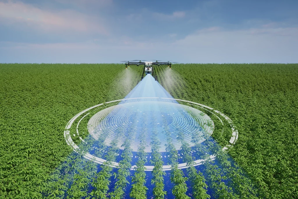
Drone LiDAR mapping is one of the most advanced uses of drone technology. It is used when aerial images alone are not enough and the job requires detailed 3D data about terrain, structures, vegetation, corridors or infrastructure.
LiDAR is powerful, but it is also easy to misunderstand. It is not magic. It does not automatically make every drone map survey-grade. It does not replace good planning, positioning, processing or validation. It is also not always better than photogrammetry.
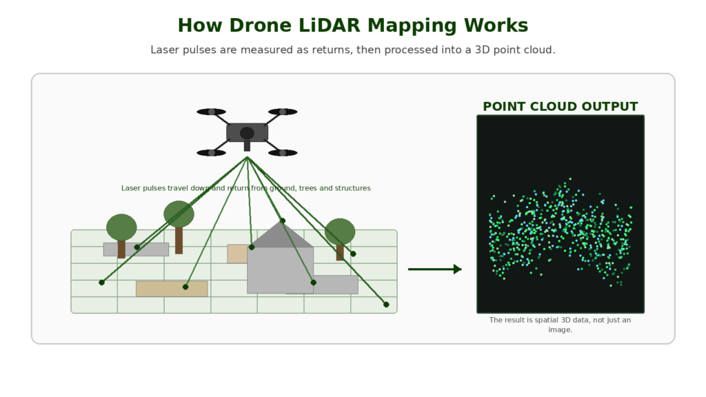
The simplest way to understand drone LiDAR is this: a LiDAR drone uses laser measurements to create 3D point cloud data. That data can then be processed into terrain models, surface models, contours, classified point clouds and other professional mapping outputs.
LiDAR becomes valuable when the work depends on height, shape, terrain, vegetation, structure or dense 3D data rather than just visual imagery.
👉 Drone Mapping Explained for UK Beginners
👉 Photogrammetry vs LiDAR: What Is the Difference in Drone Mapping?
👉 What Is a Drone Point Cloud?
Table of Contents
ToggleQuick Answer: What Is Drone LiDAR Mapping?
Drone LiDAR mapping is the process of using a drone-mounted LiDAR sensor to collect laser measurements and create 3D point cloud data.
A LiDAR sensor sends out pulses of light, measures the returns, and uses that information to build a three-dimensional representation of the mapped area. The output is usually a point cloud, which can then be processed into terrain models, surface models, contours, classified datasets or CAD/GIS-ready files.
Drone LiDAR is especially useful for:
- terrain mapping
- vegetation-heavy sites
- forestry
- powerline corridors
- railway and road corridors
- flood and drainage modelling
- quarry and earthworks mapping
- complex infrastructure
- survey-style workflows
- mapping where photogrammetry struggles
The key point is that LiDAR is a data capture method, not just a drone feature. The quality of the result depends on the sensor, drone, positioning system, IMU, RTK or PPK workflow, processing software and operator skill.
Where LiDAR Fits in Drone Mapping
Drone mapping can produce different types of outputs depending on the equipment and workflow used.
At the simplest level, a drone can capture aerial photos and video. This is useful for inspection, marketing, site records and general documentation.
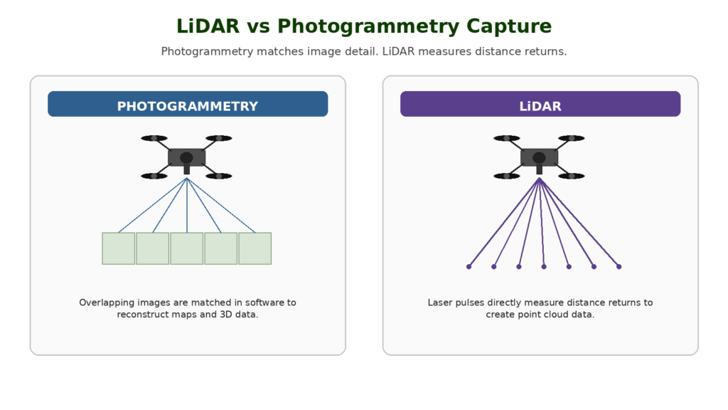
Photogrammetry goes a step further. It uses overlapping images to create outputs such as orthomosaics, 3D models and photogrammetry point clouds.
LiDAR works differently. Instead of relying on image matching, it directly measures distance using laser pulses. That makes it useful when a camera-based workflow cannot reliably capture the ground, structure or surface detail needed for the job.
| Mapping Method | Data Source | Best For |
|---|---|---|
| Normal aerial imagery | Photos and video | Visual inspection and documentation |
| Photogrammetry | Overlapping images | Orthomosaics, visual maps and 3D models |
| LiDAR | Laser measurements | Terrain, structure, vegetation and dense 3D data |
Photogrammetry is usually the better starting point for most people because it is more accessible and less expensive. LiDAR becomes more useful when the work is technical enough, valuable enough or difficult enough to justify the equipment and processing workflow.
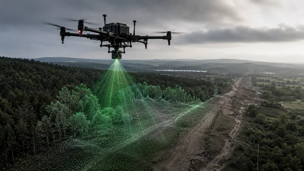
How Drone LiDAR Works
A drone LiDAR system usually combines several parts:
- drone platform
- LiDAR sensor
- GNSS positioning
- IMU motion data
- RTK or PPK correction workflow
- RGB camera in some systems
- processing software
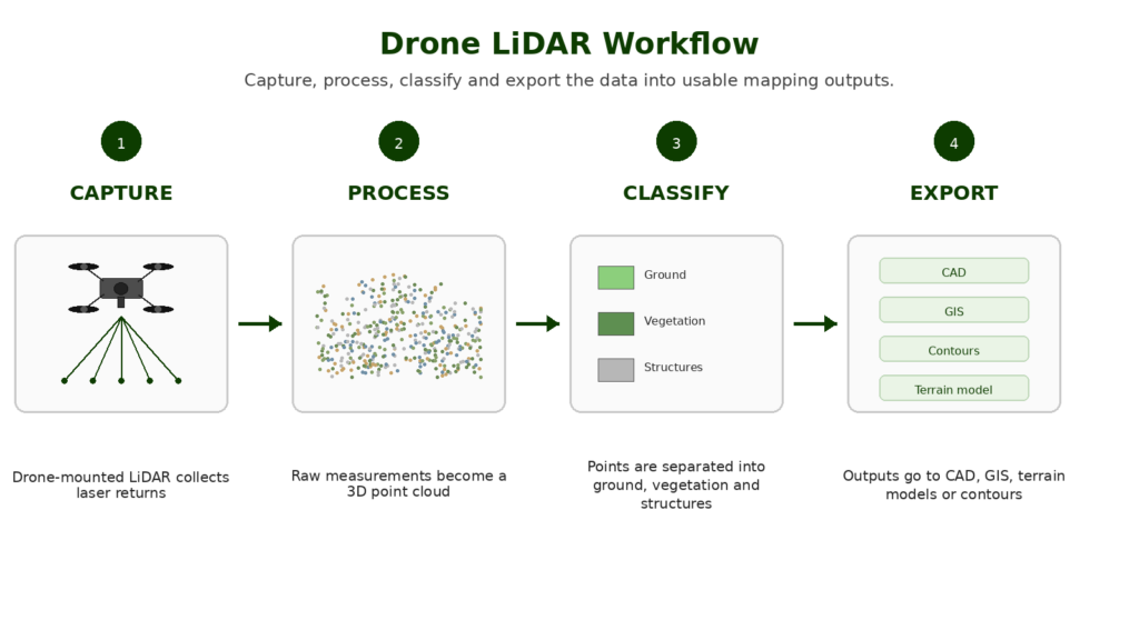
The LiDAR sensor sends out laser pulses as the drone flies. These pulses hit surfaces such as the ground, trees, buildings, stockpiles, roofs or infrastructure. The sensor measures the return data and uses it to create points in 3D space.
The IMU helps record how the sensor was moving during the flight. GNSS, RTK or PPK positioning helps place the data correctly in the real world. Processing software then turns the raw data into a usable point cloud.
That point cloud may be cleaned, classified, colourised, filtered or exported depending on the job.
This is why LiDAR mapping is more technical than ordinary drone photography. The drone is not just collecting images. It is collecting spatial data.
What Does Drone LiDAR Produce?
The main output from drone LiDAR is a point cloud.
A point cloud is a 3D dataset made from individual points. Each point has a position in space, and together those points can represent the shape of a site, surface or object.
From that point cloud, other outputs can be created, including:
- classified point clouds
- digital surface models
- digital terrain models
- contour lines
- elevation models
- cross sections
- stockpile measurements
- terrain surfaces
- CAD/GIS exports
- infrastructure models
- forestry datasets
LiDAR point clouds can also be colourised using RGB imagery if the system captures camera data alongside the laser measurements. This can make the dataset easier to interpret visually, especially for people who are not used to working with raw point cloud data.
LiDAR Point Clouds Explained Simply
A LiDAR point cloud is not a photograph. It is a collection of measured points.
Imagine a drone flying over a site and taking thousands or millions of distance measurements. Each measurement becomes a point. Together, those points form a 3D digital version of the area.
Those points can represent:
- bare ground
- trees
- buildings
- stockpiles
- roofs
- utility poles
- powerlines
- roads
- railway corridors
- slopes
- banks
- drainage features
- construction surfaces
The value of a point cloud is that it can be measured, classified and analysed. It is not just there to look impressive.
This is why point clouds are important in professional drone mapping. A drone used for mapping is not only judged by camera quality, but by the type and quality of data it can produce.
Drone LiDAR vs Photogrammetry
LiDAR and photogrammetry can both create 3D data, but they work differently.
Photogrammetry uses overlapping images. It depends on software finding matching points between photographs.
LiDAR uses laser measurements. It directly records distance returns from surfaces.
That difference affects the strengths and weaknesses of each method.
| Feature | Photogrammetry | LiDAR |
| Data source | Overlapping photos | Laser measurements |
| Main output | Orthomosaics, 3D models and point clouds | Dense point clouds, terrain and surface data |
| Visual detail | Strong colour and texture | Often needs RGB colourisation |
| Vegetation | Can struggle | Usually better through canopy gaps |
| Cost | Lower | Much higher |
| Learning curve | Easier to start | More technical |
| Best for | Visual mapping and site records | Terrain, structure, vegetation and corridors |
Photogrammetry is not basic or unprofessional, and LiDAR is not automatically superior. They are different tools.
If the output needs a clear visual map, textured 3D model or site progress record, photogrammetry may be the better choice. If the job needs terrain, vegetation performance, corridor mapping or specialist 3D data, LiDAR may be worth considering.
👉 Photogrammetry vs LiDAR: What Is the Difference in Drone Mapping?
When LiDAR Is Better Than Photogrammetry
LiDAR earns its place when photogrammetry struggles or when the job needs more specialist 3D data.
It is usually stronger for vegetation-heavy sites because photogrammetry can only reconstruct what the camera can see. If the ground is hidden by trees, scrub or vegetation, LiDAR may capture useful returns through canopy gaps.
LiDAR is also useful for terrain modelling. It is often better suited to creating ground and elevation models, especially where vegetation or surface complexity makes image matching difficult.
Corridor work is another strong use case. Powerlines, roads, railways and utility routes often involve long distances, changing ground levels, vegetation and infrastructure. LiDAR can provide useful 3D data in these environments.
Forestry is one of the clearest LiDAR applications. It can help capture canopy structure, tree height, vegetation layers and ground data in ways that ordinary imagery often cannot.
LiDAR can also be useful for complex infrastructure, quarries, earthworks, flood modelling and other high-value mapping jobs where accurate 3D structure matters.
When Photogrammetry Is Still Better
Photogrammetry is still the better choice for many jobs.
It is usually better when the site is clearly visible from above, visual detail matters, the client needs an orthomosaic, the budget is limited, or the output is mainly a site progress map or visual record.
Photogrammetry is often a strong option for:
- construction progress mapping
- roof layout context
- land records
- stockpile measurement on open sites
- visual mapping
- textured 3D models
- site documentation
- heritage records
- basic mapping practice
For many drone operators, photogrammetry is the sensible first step into mapping. It teaches the core workflow: planning, overlap, data capture, processing, accuracy and outputs.
LiDAR becomes more relevant when the site or deliverable demands it.
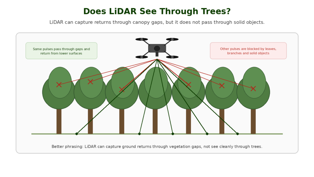
Does LiDAR See Through Trees?
This is one of the most common misunderstandings.
LiDAR does not literally see through solid tree trunks, leaves or branches as if they were transparent. What it can do is send out many laser pulses. Some of those pulses may pass through gaps in vegetation and return from lower surfaces or the ground.
That is why LiDAR can be more useful than photogrammetry in vegetation-heavy areas.
However, performance depends on several factors:
- canopy density
- leaf-on or leaf-off conditions
- sensor quality
- pulse density
- flight height
- scan angle
- processing method
- ground conditions
- required accuracy
In dense vegetation, LiDAR can still struggle. It is better to think of LiDAR as “better at capturing ground through vegetation gaps” rather than “able to see through trees”.
That distinction matters because LiDAR is powerful, but it should not be oversold.
What Drone LiDAR Is Used For
Drone LiDAR is used across several professional workflows.
In forestry and vegetation work, LiDAR can help capture tree structure, canopy height, vegetation density and ground information beneath vegetation. This makes it useful for forestry, environmental work and land management.
In terrain and drainage work, LiDAR can help create terrain models, contour data and elevation outputs. These can support drainage planning, flood context, earthworks and landform analysis.
In construction and earthworks, LiDAR can support site modelling, cut-and-fill workflows, stockpile measurement and progress tracking where 3D data matters.
In corridor and infrastructure work, LiDAR is useful for roads, railways, powerlines and utility corridors because these environments often involve long routes, vegetation, height data and complex structures.
LiDAR is also used in quarries, stockpile sites, heritage recording and complex structure mapping.
The common theme is that LiDAR becomes useful when the work depends on reliable 3D data rather than a flat image.
Do LiDAR Drones Need RTK or PPK?
For serious LiDAR mapping, accurate positioning is critical.
A LiDAR sensor measures distances, but the system also needs to know where the drone and sensor were when those measurements were taken. That is where GNSS, IMU, RTK and PPK workflows matter.
A strong LiDAR setup usually depends on:
- accurate GNSS positioning
- IMU motion data
- RTK or PPK correction
- calibration
- suitable flight planning
- careful processing
- quality checks
Without good positioning, a LiDAR point cloud can still be misaligned, noisy or unsuitable for measurement.
This is why a LiDAR drone is not just a drone with a laser scanner attached. It is a complete mapping system.
What Drone Do You Need for LiDAR Mapping?
LiDAR mapping usually requires a professional drone platform and a compatible LiDAR payload.
This is not normally a job for a standard beginner camera drone. Consumer drones can help someone learn mapping concepts, but LiDAR usually moves into enterprise equipment.
A serious LiDAR mapping setup may need:
- payload-compatible drone platform
- LiDAR sensor
- RGB camera if colourised outputs are needed
- GNSS and IMU integration
- RTK or PPK workflow
- sufficient payload capacity
- reliable flight time
- mapping software support
- strong manufacturer ecosystem
- suitable training and support
Professional LiDAR systems may combine a LiDAR sensor, IMU and RGB mapping camera into one payload. These systems are designed for more demanding mapping workflows where point cloud quality, positioning and processing matter.
The right drone depends on the output required. A buyer should not choose a LiDAR drone based only on the drone platform. The sensor, software, payload compatibility, positioning workflow and support ecosystem are just as important.
👉 Best LiDAR Drone UK
👉 Best Drone for Mapping UK
What Software Is Used for Drone LiDAR?
Drone LiDAR data needs specialist processing software.
The software may be used to:
- import raw LiDAR data
- generate point clouds
- clean noise
- colourise points
- classify ground, vegetation and structures
- create DSMs and DTMs
- produce contours
- export to CAD or GIS
- combine LiDAR and photogrammetry data
- create deliverables for clients or internal teams
Common types of software include LiDAR processing tools, photogrammetry software, GIS software, CAD software and point cloud viewers.
The software choice matters because LiDAR data can be large, technical and processing-heavy. A good drone and sensor are only useful if the data can be processed into outputs people actually need.
👉 Best Drone Mapping Software UK
Is Drone LiDAR Worth It?
Drone LiDAR is worth it when the work justifies the cost, complexity and processing requirements.
It may be worth it for:
- forestry
- vegetation-heavy sites
- terrain modelling
- utility corridors
- railways and roads
- powerlines
- flood or drainage modelling
- high-value construction data
- quarry and earthworks measurement
- specialist survey workflows
- complex infrastructure
It is probably not worth it for:
- basic aerial photos
- simple roof images
- social media footage
- beginner mapping practice
- standard orthomosaics on clear sites
- low-budget visual records
Someone considering LiDAR is not only choosing a drone. They are choosing a professional data capture workflow. That means the cost of the drone, sensor, software, training, processing, storage and support all need to be considered.
Buying Decision: LiDAR Drone or Photogrammetry Drone?
A good buying decision starts with the output, not the sensor.
Ask:
- Do you need a visual map or a 3D dataset?
- Is the ground visible?
- Is there dense vegetation?
- Is the work measurement-focused?
- Do you need terrain or surface models?
- Will the data be used in CAD or GIS?
- Is accuracy critical?
- Do you need repeatable outputs over time?
- Is the job valuable enough to justify LiDAR?
- Do you have the software and skill to process the data?
If the work mainly involves visual mapping, site records and orthomosaics, photogrammetry may be the better first investment.
If the work involves terrain, vegetation, corridors, dense 3D data or specialist survey-style workflows, LiDAR becomes much more relevant.
Common LiDAR Mistakes to Avoid
There are a few common mistakes beginners make when first learning about LiDAR.
The first is assuming LiDAR is always better than photogrammetry. It is better for certain jobs, not every job.
The second is assuming LiDAR sees cleanly through trees. It can capture returns through vegetation gaps, but canopy density and site conditions matter.
The third is buying into the technology before understanding the software workflow. Processing and interpreting the data can be as important as collecting it.
Another mistake is assuming a LiDAR point cloud is survey-grade by default. Accuracy depends on positioning, calibration, control, checkpoints and professional workflow.
It is also easy to underestimate the cost of the full setup. The sensor is only part of the investment. You may also need software, training, storage, processing power, batteries, cases, support and insurance.
The final mistake is using LiDAR where a simpler photogrammetry workflow would give the required result. Expensive technology is not always better value.
UK Drone Rules and Professional LiDAR Work
LiDAR does not change the legal basics by itself. The rules still depend on the drone, weight, class, location, operation and risk level.
Many LiDAR workflows involve larger drones, more complex sites, commercial operations, infrastructure, landowners, built-up environments or controlled areas. That means the operational side matters as much as the technology.
Some drone work may sit within the Open Category, but more complex operations may require Specific Category authorisation, insurance, permissions, risk assessment and suitable pilot competency.
This guide is for general technical information only and is not legal advice. Anyone carrying out professional LiDAR mapping in the UK should check current CAA guidance and make sure the operation is properly planned and authorised.
👉 Do You Need a Licence to Fly a Drone in the UK?
👉 Flyer ID vs Operator ID Explained
Final Verdict: Why Drone LiDAR Mapping Matters
Drone LiDAR mapping matters because it allows drones to collect serious 3D data, not just attractive aerial images.
It is especially valuable where photogrammetry struggles: vegetation, terrain, corridors, forestry, infrastructure and specialist 3D workflows.
But LiDAR is not automatically the right answer. It costs more, requires more technical skill and depends heavily on positioning, IMU data, processing and validation.
For most people, photogrammetry is the better starting point. For professional work where terrain, vegetation, structure or high-value survey-style outputs matter, LiDAR becomes a powerful tool.
The important buying lesson is simple: choose the drone and sensor based on the output you need. A LiDAR drone only makes sense when the workflow and deliverables justify it.
FAQ
What is drone LiDAR mapping?
Drone LiDAR mapping uses a drone-mounted LiDAR sensor to collect laser measurements and create 3D point cloud data.
What does LiDAR stand for?
LiDAR stands for Light Detection and Ranging.
What does a LiDAR drone produce?
A LiDAR drone usually produces a 3D point cloud. That point cloud can then be processed into terrain models, surface models, contours, classified datasets and other mapping outputs.
Is LiDAR better than photogrammetry?
LiDAR is better for some specialist jobs, especially terrain, vegetation, forestry, infrastructure and corridor mapping. Photogrammetry is often better for visual maps, orthomosaics and lower-cost mapping workflows.
Does LiDAR see through trees?
Not exactly. LiDAR does not see through solid trees, but some laser pulses may pass through gaps in the canopy and return from lower vegetation or ground surfaces.
What is a LiDAR point cloud?
A LiDAR point cloud is a 3D dataset made from laser measurements. Each point represents a measured position in space.
Do LiDAR drones need RTK?
For serious mapping, accurate positioning is very important. Many LiDAR workflows use RTK or PPK to improve positioning and support more reliable outputs.
Can a normal drone do LiDAR mapping?
No. A normal camera drone cannot do LiDAR mapping unless it has a compatible LiDAR sensor or payload system. Most consumer drones are used for imagery and photogrammetry, not LiDAR.
What is drone LiDAR used for?
Drone LiDAR is used for forestry, terrain mapping, construction, corridors, powerlines, roads, railways, quarries, infrastructure, flood modelling and specialist survey-style workflows.
Is drone LiDAR expensive?
Yes, compared with normal camera-drone mapping. LiDAR usually requires specialist sensors, compatible drone platforms, software, training and more advanced processing.
Is LiDAR worth it for drone operators?
LiDAR can be worth it for high-value professional work where terrain, vegetation, infrastructure or dense 3D data matter. It is usually not worth it for simple visual mapping or beginner drone use.
What software is used for drone LiDAR?
Drone LiDAR software may include LiDAR processing tools, photogrammetry software, GIS software, CAD software and point cloud viewers.
Can LiDAR and photogrammetry be used together?
Yes. Some workflows combine LiDAR point clouds with RGB imagery or photogrammetry data to create richer and easier-to-interpret outputs.
Is drone LiDAR survey-grade?
Not automatically. Survey-grade outputs depend on the full workflow, including equipment, positioning, calibration, control, checkpoints, processing and professional competence.
What is the best drone for LiDAR mapping?
The best drone for LiDAR mapping depends on the payload, accuracy requirements, software workflow, site type and budget. Enterprise drone platforms with compatible LiDAR payloads are usually required for serious LiDAR work.