Choosing the best drone for mapping is not the same as choosing the best drone for photography. A good mapping drone needs to capture consistent, accurate, processable data — not just attractive aerial images.
That means camera quality matters, but it is only part of the decision. For proper drone mapping, you also need to think about mechanical shutter, RTK or PPK support, mapping software compatibility, image overlap, flight planning, battery life, ground control, point clouds, orthomosaics and whether the job needs photogrammetry or LiDAR.
For most professional mapping work in the UK, the best overall mapping drone is the DJI Matrice 4E. It is the mapping-focused model in DJI’s compact Matrice 4 series and is designed for surveying, mapping, construction and mining-style workflows.
For buyers who want a smaller and more established mapping platform, the DJI Mavic 3 Enterprise is still one of the most practical choices. For LiDAR mapping, a drone alone is not enough — you need a compatible enterprise platform and a LiDAR payload such as the DJI Zenmuse L2.
This guide explains which mapping drone to buy depending on whether you need basic photogrammetry, RTK mapping, construction mapping, point clouds or LiDAR data.
👉 Drone Mapping Explained for UK Beginners
👉 Photogrammetry vs LiDAR: What Is the Difference in Drone Mapping?
👉 RTK vs PPK Drones Explained
Table of Contents
ToggleQuick Answer: Best Drone for Mapping UK
The best overall drone for mapping in the UK is the DJI Matrice 4E. It is the strongest all-round choice for professional photogrammetry, RTK mapping, construction mapping, orthomosaics and survey-style workflows.
The best compact mapping drone is the DJI Mavic 3 Enterprise. It remains a very practical option for professional mapping because of its 4/3 camera, mechanical shutter, RTK support and established enterprise ecosystem.
The best drone for learning basic mapping concepts is the DJI Air 3S. It is not a professional mapping drone, but it is useful for understanding flight planning, image overlap and basic photogrammetry before investing in enterprise equipment.
The best LiDAR mapping setup is a DJI Matrice 350 RTK or Matrice 400 with Zenmuse L2, depending on budget, supplier advice and platform requirements.
The best mapping drone for thermal and inspection overlap is the DJI Matrice 4T, but it is not the best pure mapping choice. Choose the Matrice 4E for mapping and the Matrice 4T for thermal inspection.
Best Drones for Mapping UK: Quick Picks
These recommendations are based on typical UK drone mapping workflows, including photogrammetry, RTK mapping, construction mapping, LiDAR data capture, portability, software compatibility and professional support. No single drone is best for every mapping job, so the strongest choice depends on the output you need.
| Use Case | Best Drone | Why |
|---|---|---|
| Best overall for professional mapping | DJI Matrice 4E | Strongest choice for photogrammetry, RTK mapping, construction mapping and geospatial workflows |
| Best compact professional mapping drone | DJI Mavic 3 Enterprise | Portable, proven and well suited to orthomosaics, photogrammetry and RTK workflows |
| Best drone for learning mapping | DJI Air 3S | Useful for learning flight planning, image overlap and basic photogrammetry before buying enterprise equipment |
| Best for thermal inspection and mapping overlap | DJI Matrice 4T | Better suited to thermal inspection, solar, roof and public safety-style work than pure mapping |
| Best LiDAR mapping setup | Matrice platform with Zenmuse L2 | Suitable for LiDAR point clouds, terrain, vegetation, corridors and specialist 3D workflows |
For most serious mapping buyers, the decision is between the DJI Matrice 4E and the DJI Mavic 3 Enterprise. Choose the Matrice 4E if mapping is the main job. Choose the Mavic 3 Enterprise if portability and a compact professional workflow matter more.
Best Overall Mapping Drone: DJI Matrice 4E
The DJI Matrice 4E is the best overall drone for professional mapping in the UK.
It is the mapping-focused model in the Matrice 4 series, and that distinction matters. The Matrice 4T is better known for thermal and inspection work, but the Matrice 4E is the model aimed at geospatial tasks such as surveying, mapping, construction and mining.
For drone mapping, the Matrice 4E is the better pick because it is built around photogrammetry and accurate data capture rather than just visual inspection.
Why the Matrice 4E is the best mapping choice
The Matrice 4E is well suited to:
- orthomosaic mapping
- construction site mapping
- photogrammetry
- RTK workflows
- mining and quarry mapping
- land and estate mapping
- point cloud generation from imagery
- repeated site mapping
- survey-style data capture
- mapping where image consistency matters
A good mapping drone needs repeatable image capture. The Matrice 4E’s wide camera, mechanical shutter, RTK support and enterprise workflow make it a stronger mapping choice than consumer drones that may have impressive image specs but are not designed around mapping capture.
Who should buy it?
Buy the DJI Matrice 4E if mapping is a serious professional use case and you need a drone built for photogrammetry, orthomosaics, RTK mapping and structured site data.
Do not buy it if you only want to learn mapping basics or take occasional aerial site photos. It is a professional tool.
👉 Learn more about the DJI Matrice 4E
👉 What Is a Drone Orthomosaic?
👉 What Is a Drone Point Cloud?
Best Compact Mapping Drone: DJI Mavic 3 Enterprise
The DJI Mavic 3 Enterprise is the best compact professional mapping drone.
It is not the newest enterprise mapping option, but it remains one of the most practical choices because it is portable, proven and designed for mapping workflows.
The Mavic 3 Enterprise has been widely used for photogrammetry, construction mapping, site documentation and orthomosaic generation. It is a sensible choice for buyers who want professional mapping capability without moving straight into the Matrice 4E.
Why it suits mapping
The Mavic 3 Enterprise is useful for:
- photogrammetry
- orthomosaics
- construction site records
- roof and site mapping
- land mapping
- estate mapping
- point clouds from imagery
- RTK workflows with the right setup
- repeatable site documentation
Its biggest advantage is portability. A mapping drone that is easy to transport and deploy is more likely to be used regularly. For many operators, that matters.
Limitations
The Mavic 3 Enterprise is no longer the strongest mapping drone overall. The Matrice 4E is the better choice if you are buying primarily for professional mapping now.
However, the Mavic 3 Enterprise remains a good option where budget, portability or existing ecosystem familiarity matter.
Who should buy it?
Buy the DJI Mavic 3 Enterprise if you want a compact, practical and proven professional mapping drone.
👉 Learn more about the DJI Mavic 3 Enterprise
👉 RTK vs PPK Drones Explained
Best Drone for Learning Mapping: DJI Air 3S
The DJI Air 3S is the best option for learning drone mapping concepts before moving into enterprise equipment.
It is not a professional mapping drone. It does not replace a Matrice 4E or Mavic 3 Enterprise. But it can be useful for learning the basics of aerial data capture, flight planning, image overlap, site photography and simple photogrammetry practice.
For beginners, the biggest mistake is buying expensive enterprise equipment before understanding the workflow. Mapping is not just about owning the drone. It is about planning, capture, overlap, processing, accuracy and outputs.
The Air 3S is a practical learning drone because it is capable, portable and less expensive than enterprise mapping platforms.
What it can teach
The Air 3S can help users understand:
- mapping flight planning
- image overlap
- ground sampling distance
- site records
- aerial photography for mapping
- basic photogrammetry concepts
- why camera angle and lighting matter
- why processing software matters
- why professional mapping needs more than a good camera
Limitations
The Air 3S should not be treated as a professional mapping drone. It is not the best choice for accurate RTK mapping, professional orthomosaics, survey-style outputs or commercial mapping reports.
It is a learning option, not the final professional setup.
Who should buy it?
Buy the DJI Air 3S if you want to learn mapping concepts before investing in a dedicated mapping drone.
Best Drone for Photogrammetry: DJI Matrice 4E
The best drone for photogrammetry is the DJI Matrice 4E.
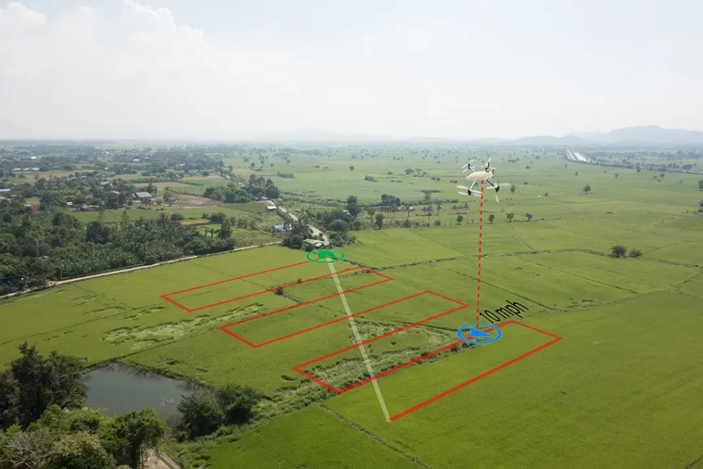
Photogrammetry depends on consistent overlapping images. The drone captures a structured set of photos, and mapping software uses those images to create outputs such as orthomosaics, 3D models and point clouds.
For this work, the Matrice 4E is stronger than consumer camera drones because it is designed around mapping capture.
A good photogrammetry drone needs:
- sharp still images
- reliable flight planning
- mechanical shutter
- RTK or PPK workflow support
- consistent image capture
- mapping software compatibility
- good flight time
- stable positioning
- suitable controller and mission tools
- support from an enterprise ecosystem
The Matrice 4E is the best fit because it is built for this type of work.
👉 Photogrammetry vs LiDAR: What Is the Difference in Drone Mapping?
Best RTK Mapping Drone: DJI Matrice 4E
The best RTK mapping drone is also the DJI Matrice 4E.
RTK matters when mapping accuracy, repeatability and positioning are important. It improves the position data associated with images or sensor readings, which can help with georeferencing and mapping workflows.
RTK does not make a drone map accurate by magic. It still needs correct flight planning, suitable overlap, good processing, checkpoints and a proper workflow. But it is an important feature for serious mapping.
The Matrice 4E is the strongest recommendation because it combines mapping-focused camera capability with RTK-ready enterprise workflow.
The DJI Mavic 3 Enterprise remains a good compact RTK mapping choice, especially where portability matters.
Best Drone for Construction Mapping: DJI Matrice 4E
The best drone for construction mapping is the DJI Matrice 4E.
Construction mapping often needs repeated flights, site progress records, orthomosaics, stockpile context, earthworks documentation and clear visual comparison over time.
A normal camera drone can capture useful site images, but construction mapping becomes more valuable when the data is captured consistently and processed into usable outputs.
The Matrice 4E is well suited to:
- construction site orthomosaics
- progress mapping
- earthworks records
- stockpile context
- site access mapping
- repeated site flights
- 3D models from photogrammetry
- contractor and client reporting
For smaller construction sites or users who value portability, the DJI Mavic 3 Enterprise is still a strong alternative.
Best Drone for LiDAR Mapping: Matrice Platform with Zenmuse L2
The best drone for LiDAR mapping is not a single normal camera drone. It is a compatible Matrice platform with a LiDAR payload.
For DJI users, the key setup is a Matrice 350 RTK or Matrice 400 with Zenmuse L2, depending on platform choice, supplier advice and budget.
LiDAR mapping is different from photogrammetry. Instead of using overlapping images, LiDAR uses laser measurements to create point clouds. This is useful for terrain, vegetation, corridors, forestry, infrastructure and specialist survey-style workflows.
LiDAR mapping may be useful for:
- forestry
- terrain mapping
- powerline corridors
- road and rail corridors
- quarries
- flood modelling
- utility routes
- vegetation-heavy sites
- high-end point cloud work
- specialist survey workflows
A buyer should not choose a LiDAR setup casually. The drone, LiDAR sensor, IMU, GNSS, RTK or PPK workflow, processing software and operator skill all matter.
👉 Drone LiDAR Mapping Explained
👉 What Is a Drone Point Cloud?
Best Mapping Drone for Thermal and Inspection Overlap: DJI Matrice 4T
The DJI Matrice 4T is not the best pure mapping drone, but it is the best choice when mapping overlaps with thermal inspection.
This is an important distinction.
Choose the Matrice 4E if the main job is mapping, photogrammetry, construction, mining or survey-style data capture.
Choose the Matrice 4T if the main job involves thermal imaging, inspection, public safety, search, solar panels, electrical assets or roof thermal work.
The Matrice 4T can still support some mapping and documentation workflows, but its strength is inspection rather than pure photogrammetry.
What Makes a Good Mapping Drone?
A good mapping drone is judged by data quality, not just camera marketing.
Important features include:
- camera sensor quality
- mechanical shutter
- RTK or PPK support
- consistent image capture
- reliable flight planning
- mapping software compatibility
- good battery life
- stable flight
- controller and mission tools
- accurate geotagging
- ecosystem support
- spare batteries and servicing
- ability to export useful data
For beginners, the biggest trap is assuming any drone with a high-resolution camera is a mapping drone. It is not.
A drone used for mapping must capture data in a way that can be processed reliably.
Mechanical Shutter: Why It Matters
A mechanical shutter matters in drone mapping because it helps reduce rolling shutter distortion during image capture.
Photogrammetry relies on matching details between overlapping images. If images are distorted, blurred or inconsistent, the software has a weaker dataset to process.
This is why mapping-focused drones such as the Matrice 4E and Mavic 3 Enterprise are stronger choices than consumer drones that may look impressive for video but are not built primarily for mapping.
A mechanical shutter is not the only feature that matters, but it is one of the strongest signs that a drone is genuinely suitable for photogrammetry work.
Photogrammetry vs LiDAR: Which Drone Do You Need?
Most people should start with photogrammetry.
Photogrammetry is the better choice for:
- orthomosaics
- visual maps
- construction progress
- open site mapping
- roof and building context
- 3D models from images
- land and estate mapping
- basic stockpile work
- lower-cost mapping workflows
LiDAR is better for:
- vegetation-heavy sites
- forestry
- terrain models
- corridors
- utilities
- powerlines
- railways
- flood modelling
- specialist point cloud workflows
- high-value survey-style work
The right choice depends on the output.
If the output is a visual map or orthomosaic, choose a photogrammetry drone such as the Matrice 4E or Mavic 3 Enterprise.
If the output is a LiDAR point cloud or bare-earth terrain model under vegetation, look at a Matrice platform with a LiDAR payload.
Do You Need RTK or PPK?
You do not always need RTK or PPK to learn mapping, but they become important when accuracy matters.
RTK and PPK help improve positioning data. This can be useful for:
- professional orthomosaics
- repeat site mapping
- construction progress
- mapping tied to coordinates
- point clouds
- survey-style workflows
- reducing reliance on ground control in some workflows
RTK or PPK does not remove the need for good practice. Checkpoints, ground control, processing settings and validation still matter.
For casual learning, a non-RTK drone can teach the basics. For professional mapping, choose a drone with proper RTK or PPK support.
Mapping Drone Features Compared
| Feature | Why It Matters |
| Mechanical shutter | Reduces image distortion for photogrammetry |
| RTK / PPK support | Improves positioning workflows |
| Good still image quality | Helps mapping software match features |
| Mapping software compatibility | Needed for mission planning and processing |
| Flight time | Helps cover larger sites efficiently |
| Stable hover and flight | Improves image consistency |
| Reliable controller | Helps plan and monitor missions |
| Enterprise support | Important for paid or professional work |
| LiDAR payload support | Needed for laser-based point clouds |
| Thermal sensor | Useful for inspection, not pure mapping |
| Battery ecosystem | Important for repeat site work |
Which Mapping Drone Should You Buy?
Buy the DJI Matrice 4E if you want the best overall professional mapping drone.
Buy the DJI Mavic 3 Enterprise if you want a compact, proven and portable mapping drone.
Buy the DJI Air 3S if you want to learn mapping concepts before buying enterprise equipment.
Buy the DJI Matrice 4T if the work is more about thermal inspection than pure mapping.
Buy a Matrice 350 RTK or Matrice 400 with Zenmuse L2 if you need LiDAR point cloud data.
For most serious buyers, the recommendation is clear:
Choose the Matrice 4E for mapping. Choose the Matrice 4T for thermal inspection. Choose the Mavic 3 Enterprise for compact professional mapping.
UK Rules for Drone Mapping
Drone mapping in the UK must be planned around the rules, not just the equipment.
The requirements depend on the drone, location, weight, class, airspace, people nearby, operating environment and risk level.
Some lower-risk mapping work may fit within the Open Category. More complex work may require Specific Category authorisation, insurance, site permission, risk assessment and suitable pilot competency.
Mapping work often takes place around land, buildings, construction sites, commercial premises, industrial areas or infrastructure. That makes planning important.
Privacy and data protection can also matter. Drone mapping may capture neighbouring land, buildings, people, vehicles or business sites. Professional mapping work should be planned and handled responsibly.
This guide is for general technical information only and is not legal advice. Always check current UK CAA guidance before carrying out drone mapping work.
👉 Do You Need a Licence to Fly a Drone in the UK?
👉 Flyer ID vs Operator ID Explained
Where to Buy a Mapping Drone in the UK
For mapping drones, specialist suppliers usually make more sense than chasing the cheapest listing.
A mapping drone is part of a workflow. You may need:
- RTK module
- base station or correction service
- mapping software
- spare batteries
- maintenance support
- training
- insurance
- processing workflow
- ground control equipment
- support with export formats
For enterprise models such as the Matrice 4E, Mavic 3 Enterprise or Matrice platforms with LiDAR payloads, use an authorised drone supplier with proper support.
For learning drones such as the Air 3S, consumer retailers may be fine. For professional mapping, support matters.
Best Drone for Mapping UK: Final Verdict
The best drone for mapping in the UK is the DJI Matrice 4E.
It is the strongest all-round choice for professional photogrammetry, RTK mapping, construction site mapping, orthomosaics and survey-style data capture.
The DJI Mavic 3 Enterprise remains the best compact mapping drone and is still a very sensible choice for many operators.
The DJI Air 3S is the best option for learning mapping concepts, but it is not a professional mapping drone.
For LiDAR, choose a compatible Matrice platform with Zenmuse L2 rather than trying to force a normal camera drone into a LiDAR workflow.
The key buying lesson is simple: choose the drone based on the mapping output you need. Orthomosaics, 3D models, RTK mapping, point clouds and LiDAR data all place different demands on the drone.
FAQ
What is the best drone for mapping in the UK?
The best overall drone for mapping in the UK is the DJI Matrice 4E. It is designed for professional mapping, surveying, construction and geospatial workflows.
What is the best compact drone for mapping?
The DJI Mavic 3 Enterprise is the best compact professional mapping drone. It is portable, proven and suitable for photogrammetry and RTK mapping workflows.
Can I use a normal drone for mapping?
Yes, a normal drone can be used to learn basic mapping concepts if it captures suitable overlapping images. For professional mapping, a dedicated enterprise mapping drone is much better.
Is the DJI Air 3S good for mapping?
The DJI Air 3S is useful for learning mapping concepts and capturing basic visual site records. It is not the best choice for professional mapping or RTK workflows.
Is the DJI Mini 4 Pro good for mapping?
The DJI Mini 4 Pro can be used for basic learning and simple image capture, but it is not a professional mapping drone. The Air 3S is a better learning option, and the Mavic 3 Enterprise or Matrice 4E are better professional options.
Is the DJI Mavic 3 Enterprise still worth buying?
Yes. The DJI Mavic 3 Enterprise is still worth buying if you want a compact and proven mapping drone. The Matrice 4E is the stronger current mapping choice, but the Mavic 3 Enterprise remains practical.
Is the Matrice 4E better than the Mavic 3 Enterprise?
Yes, for serious mapping, the DJI Matrice 4E is the stronger current choice. The Mavic 3 Enterprise is better where portability, budget or an established compact workflow matter more.
What is the best drone for photogrammetry?
The DJI Matrice 4E is the best photogrammetry drone in this guide. The DJI Mavic 3 Enterprise is the best compact alternative.
What is the best RTK drone for mapping?
The DJI Matrice 4E is the best RTK mapping drone overall. The DJI Mavic 3 Enterprise is a strong compact RTK mapping option.
What is the best drone for LiDAR mapping?
For LiDAR mapping, use a compatible Matrice platform with a LiDAR payload such as Zenmuse L2. A normal camera drone cannot do true LiDAR mapping without a LiDAR sensor.
Do I need LiDAR for drone mapping?
Not usually. Most mapping starts with photogrammetry. LiDAR is useful for vegetation, terrain, forestry, corridors, utilities and specialist point cloud workflows.
Do I need RTK for drone mapping?
Not always. RTK is not required for basic learning, but it is important for professional mapping where positioning, repeatability and accuracy matter.
What is a mechanical shutter and why does it matter?
A mechanical shutter helps reduce image distortion during capture. This is useful for photogrammetry because mapping software relies on consistent overlapping images.
Can drone mapping be survey-grade?
Drone mapping can support survey-style workflows, but survey-grade outputs depend on the full workflow, including equipment, control, checkpoints, processing and professional competence.
Do you need a licence for drone mapping in the UK?
It depends on the drone, location and operation. Some mapping work may fit within the Open Category, while more complex work may require Specific Category authorisation, insurance and permissions.
What software do mapping drones use?
Mapping drones may use software such as DJI Terra, Pix4D, DroneDeploy, Agisoft Metashape, ArcGIS, CloudCompare and other photogrammetry, GIS or CAD tools.